Locations Schema and RMIS Atlas
The Location Code itself was defined historically as a record identifier with an internal hierarchical structure – a ‘schema’ – which allows multiple reporting agencies to maintain their own sets of locations within the same RMIS table. This multi-agency schema is defined on the left below.
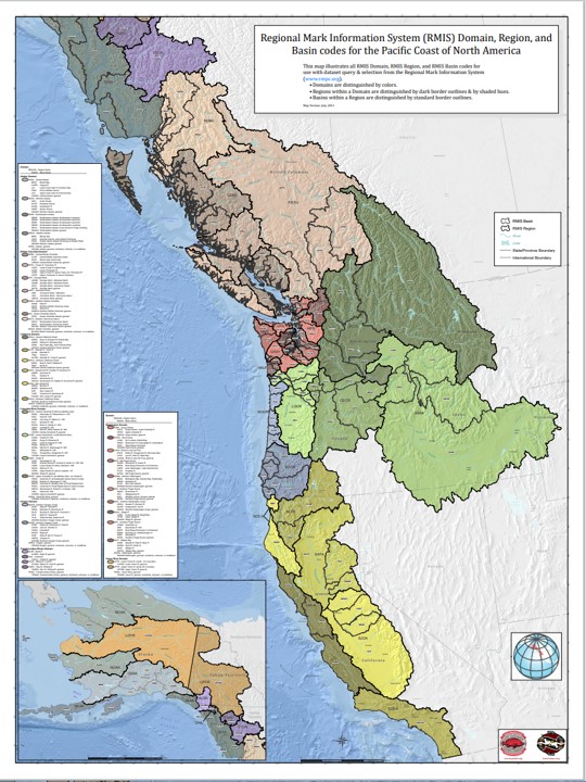
Many locations in RMIS are also included in the RMIS Atlas. These are: Release Site (Location Type ‘4’), Hatchery/Facility (Location Type ‘3’), and Recovery Site (Location Type ‘1’). The remaining Location Types: Catch Area (Location Type ‘2’), and Stock (Location Type ‘5’) – are not included in the RMIS Atlas. The RMIS Atlas consists of the following areas (watershed-based polygons): RMIS Domains, RMIS Regions, and RMIS Basins. These geographic areas can be used for querying Release or Recovery data from RMIS. The RMIS Domains — coastwide — are illustrated on the right below.
Further details on geographic locations in RMIS are provided below using the interactive map and in the documents at the bottom of this page.
Agencies Location Coding Schema
All location codes are standardized within a given State or Province, and coordinated by the State/Province. These location codes are alphanumeric codes used to identify hatchery, release location, recovery site, catch area, or stock and are based on hierarchical scheme to give multiple levels of resolution.
State/Country: Alaska, USA
RMIS Acronym: ADFG
Location Coding Schema
(for details and maps see the 1988 Locations Schema document)
A 19-character location strip is being used by all parties to the Pacific Salmon Treaty to geographically identify the locations of salmon stocks, hatcheries, release sites, recovery sites and sampling sites, coastwide.
In Alaska the following outline describes the conventions used in coding each part of the location strip. In general, the schemes follow existing formats defined by Division of Commercial Fisheries and Division of Habitat. Data collected under authority of Division of FRED and Division of Sportfish have generally been mapped into the Commercial Fisheries scheme.
Level 0 – State
Level 1 – Water Type
Level 2 – Salmon Management Region
Level 3 – Quadrant
Level 4 – District
Level 5 – Sub district (statistical subarea)
Level 6 – Sub strata (habitat stream code)
Country: Canada
RMIS Acronym: CDFO
Location Coding Schema
(for details and maps see the 1988 Locations Schema document)
A 19-character location strip is being used by all parties to the
Pacific Salmon Treaty to geographically identify the locations of
salmon stocks, hatcheries. release sites, recovery sites and sampling sites. coastwide.
Level 0 – Province
Level 1 – Water Type
Level 2 – Location
Level 3 – Catch region
Level 4 – Event (statistical or production area)
Level 5 – Usage (expansion level for freshwater events dependent to Level 1)
Level 6 – Usage (subarea code)
State/Country: California, USA
RMIS Acronym: CDFW
Location Coding Schema
(for details and maps see the 1988 Locations Schema document)
Level 0 – State
Level 1 – Water Type
Level 2 – Sector
Level 3 – Region
Level 4 – Statistical area
Level 5 – Location
Level 6 – Sub-location
State/Country: Idaho, USA
RMIS Acronym: IDFG
Location Coding Schema
for details and maps see the 1988 Locations Schema document
State/Country: Alaska, USA
RMIS Acronym: NMFS
Location Coding Schema
for details and maps see the 1988 Locations Schema document
State/Country: Oregon, USA
RMIS Acronym: ODFW
Location Coding Schema
(for details and maps see the 1988 Locations Schema document)
A 19-character location strip is being used by all parties to the
Pacific Salmon Treaty to geographically identify the locations of salmon stocks, hatcheries, release sites, recovery sites and sampling sites, coastwide.
In Oregon the following outline describes the conventions used in
coding each part of the location strip.
Level 0 – State
Level 1 – Water Type
Level 2 – Sector
Level 3 – Region
Level 4 – Statistical area
Level 5 – Location
Level 6 – Sub-location
State/Country: Washington, USA
RMIS Acronym: WDFW
Location Coding Schema
(for details and maps see the 1988 Locations Schema document)
A 19-character location strip is being used by all parties to the
Pacific Salmon Treaty to geographically identify the locations of
salmon stocks, hatcheries, release sites, recovery sites and sampling sites, coastwide. In Washington State, the following outline describes the conventions used in coding each part of the location strip. Where possible,
existing coding schemes used by Salmon Culture, Harvest Management, and existing data storage formats have been incorporated into the PST location strip.
Level 0 – State
Level 1 – Water Type
Level 2 – Sector
Level 3 – Region
Level 4 – Statistical area
Level 5 – Location
Level 6 – Sub-location
RMIS Atlas: Domains
RMPC also created a set of standardized geographic areas to enhance access to coded wire tag data through the RMIS queries that are comprised of 8 domains each consisting of regions and basins.
Documents Related to Locations and RMPC Maps
| File | Description | File Date |
|---|---|---|
| Specifications and Definitions for the Exchange of Coded Wire Tag Data for the North American Pacific Coast PSC Format Version 5.0 | CWT data submitted to RMIS must be exchanged in the form of a PSC Format Version 5.0 dataset. The definition and specification of PSC Format Version 5.0 is described in this document. | 2026 |
| RMIS California Domain Atlas | RMPC developed this map set of the California Domain to improve access to coded wire tag data through the RMIS query tool | 2011 |
| Poster of CWT Releases in the Pacific Northwest (1968-2007) | The number of coded wire tags that were released in the Pacific Northwest (RMPC Domains: British Columbia, Columbia River, Oregon, and Washington) between 1968 through 2007 for salmon and steelhead species. | 2008 |
| Poster of CWT Releases in the Pacific Northwest (1968-2007) low resolution version | The number of coded wire tags that were released in the Pacific Northwest (RMPC Domains: British Columbia, Columbia River, Oregon, and Washington) between 1968 through 2007 for salmon and steelhead species. | 2008 |
| Poster of CWT Releases in the Pacific Coastal region (1968-2007) | The number of coded wire tags that were released in the Pacific Northwest (RMPC Domains: Alaska, British Columbia, California, Columbia River, Oregon Coast, Washington, and Yukon) between 1968 through 2007 for salmon and steelhead species. | 2008 |
| Poster of CWT Releases in the Pacific Coastal region (1968-2007) low resolution version | The number of coded wire tags that were released in the Pacific Northwest (RMPC Domains: Alaska, British Columbia, California, Columbia River, Oregon Coast, Washington, and Yukon) between 1968 through 2007 for salmon and steelhead species. | 2008 |
| Index of the RMIS Domain Maps (high resolution image) | This is an INDEX to the RMIS Domain Maps developed by the RMPC to improve access to coded wire tag data through the RMIS query tool | 2011 |
| Index of the RMIS Domain Maps (medium resolution image) | This is an INDEX to the RMIS Domain Maps developed by RMPC to improve access to coded wire tag data through the RMIS query tool | 2011 |
| RMIS Yukon Domain Atlas | RMPC developed this map set of the Yukon Domain to improve access to coded wire tag data through the RMIS query tool | 2011 |
| RMIS Washington Domain Atlas | RMPC developed this map set of the Washington Domain to improve access to coded wire tag data through the RMIS query tool | 2011 |
| RMIS Transboundary Rivers Domain Atlas | RMPC developed this map set of the Transboundary Rivers Domain to improve access to coded wire tag data through the RMIS query tool | 2011 |
| RMIS Oregon Domain Atlas | RMPC developed this map set of the Oregon Domain to improve access to coded wire tag data through the RMIS query tool | 2011 |
| RMIS Columbia River Basin Domain Atlas | RMPC developed this map set of the Columbia River Basin Domain to improve access to coded wire tag data through the RMIS query tool | 2011 |
| RMIS British Columbia Domain Atlas | RMPC developed this map set of the British Columbia Domain to improve access to coded wire tag data through the RMIS query tool | 2011 |
| RMIS Alaska Domain Atlas | RMPC developed this map set of the Alaska Domain to improve access to coded wire tag data through the RMIS query tool | 2011 |
| PSC Location Coding Scheme used by Agencies and Tribes | Appendix 4.4 of the Pacific Salmon Commission Joint Technical Committee on Data Sharing Joint Working Group on Mark Recovery Databases, Report TCDS (89) - 1. Information Content and Data Standards for a Coastwide Coded-Wire Tag Database. Each agency and tribe describes the code applied to their locations and provides maps illustrating each locations. | 1989 |